


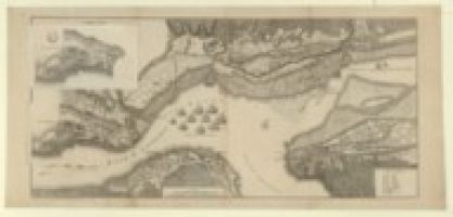
Carte ancienne "A correct plan of the environs of Québec and of the battle fought on the 13th September 1759"
GRATUIT
Auteur : Jefferys, Thomas (1719?-1771). Cartographe
Date d'édition : 1759
Sujet : Bateaux à voiles
Sujet : Beauport
Sujet : Orleans, Île d'
Sujet : Québec -- Siège -- 1759
Sujet : Saint-Laurent (cours d'eau)
Type : document cartographique,document cartographique manuscrit,image fixe
Langue : Anglais
Format : 1 carte : en noir et blanc ; 46 x 100 cm
Droits : domaine public
Source : Bibliothèque nationale de France, département Cartes et plans
Description : Échelle(s) : Echelle de 7 200 pieds [0,12]
2.15 MB
Connectez-vous ou créez un compte gratuit pour télécharger gratuitement